Radar satellites: the view of RADARSAT-2 (C Band) in Paraná River wetlands
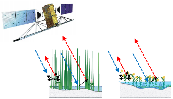
My main research topic involves wetlands and remote sensing, including applications of radar satellite imagery. Here I share the results of a study that aimed to understand the interaction between the signal of a satellite radar system (active microwave SAR), RADARSAT-2 (operating at C-Band frequency) and the herbaceous vegetation of the Lower Paraná River floodplain. One of the advantages of radar systems versus other satellite types is that the signal can penetrate vegetation and detect the presence of surface water. Thus, the use of radar satellite data is relevant for hydrological monitoring and to assess the state and dynamics of wetland ecosystems.
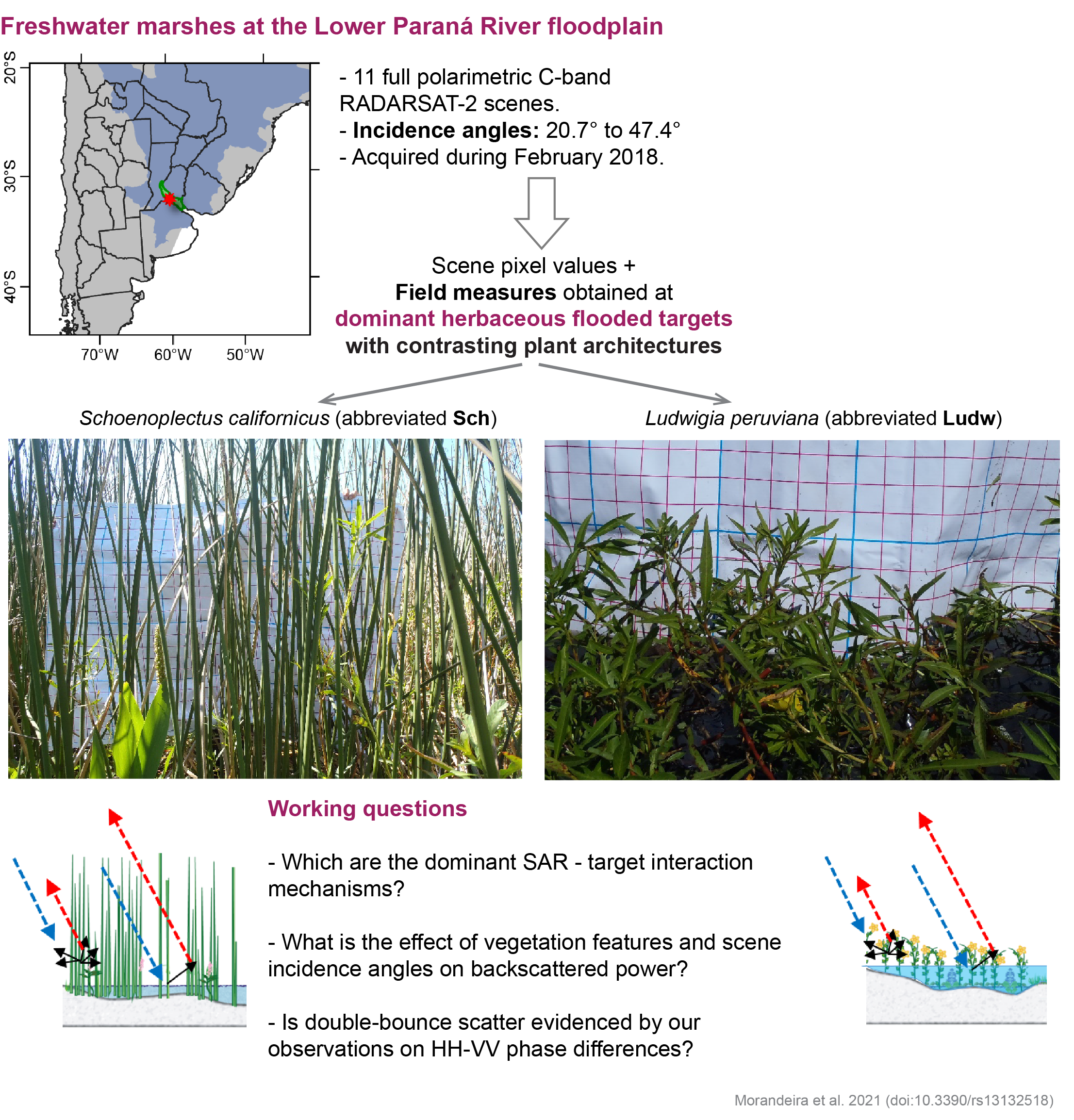
We studied two dominant vegetation types: Bulrush marshes with Schoenoplectus californicus and Broadleaf marshes with Ludwigia peruviana. The sites were flooded at the time we sampled them and also when SAR imagery was acquired. Full polarimetric SAR data were used; this means that the satellite data has extra information compared to other SAR data (both vertical and horizontal signal polarizations are emitted and sensed). In comparison terms, the Argentinian mission SAOCOM is also full polarimetric, but may have greater penetration through vegetation layers because it operates at L-Band instead of C-Band.
Our questions were: What is the effect of vegetation features, such as biomass, stem density, emergent height, stem diameter?; What happens when the SAR observation mode changes (scenes acquired with different incidence angles)?; Is water presence evidenced through the analysis of the polarimetric information (according to fitted models of the HH-VV phase differences)?
To answer these questions, I worked in collaboration with collegues from the Instituto de Astronomía y Física del Espacio, UBA-CONICET (Matías Barber and Francisco Grings), from my Instituto de Investigación e Ingeniería Ambiental, UNSAM (Patricia Kandus) and from two Canadian institutions: TerreVista Imaging (Frank Ahern) and Canada Centre for Mapping and Earth Observation - Natural Resources Canada (Brian Brisco).
Publication
In 2019, I presented preliminary results in ASAR 2019: A workshop on Synthetic Aperture Radar (Canadian Space Agency), thanks to the Programa de Movilidad para Docentes e Investigadores de la Universidad Nacional de San Martín who funded my participation in the workshop.
The work was published in the open-access scientific journal Remote Sensing (MDPI editorial) in 2021: “Response of Multi-Incidence Angle Polarimetric RADARSAT-2 Data to Herbaceous Vegetation Features in the Lower Paraná River Floodplain, Argentina”.
Abstract
This is the abstract of the published article. An Spanish version is provided in this website.
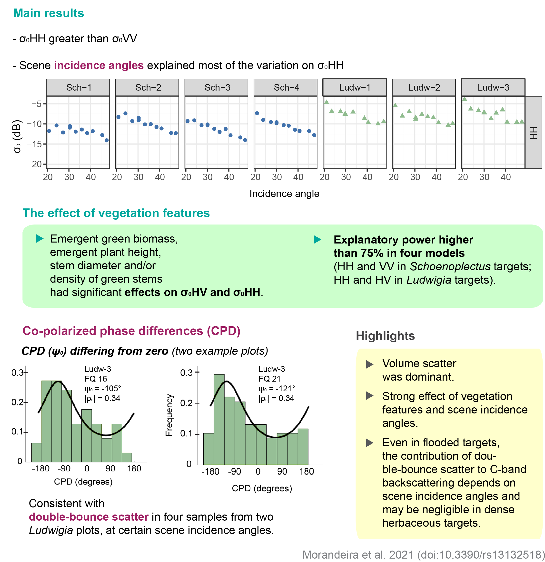
Abstract. Wetland ecosystems play a key role in hydrological and biogeochemical cycles. In emergent vegetation targets, the occurrence of double-bounce scatter is indicative of the presence of water and can be valuable for hydrological monitoring. Double-bounce scatter would lead to an increase of σ0HH over σ0VV and a non-zero co-polarized phase difference (CPD). In the Lower Paraná River floodplain, a total of 11 full polarimetric RADARSAT-2 scenes from a wide range of incidence angles were acquired during a month. Flooded targets dominated by two herbaceous species were sampled: Schoenoplectus californicus (four sites, Bulrush marshes) and Ludwigia peruviana (three sites, Broadleaf marshes). As a general trend, σ0HH was higher than σ0VV, especially at the steeper incidence angles. By modeling CPD with maximum likelihood estimations, we found results consistent with double-bounce scatter in two Ludwigia plots, at certain scene incidence angles. Incidence angle accounted for most of the variation on σ0HH, whereas emergent green biomass was the main feature influencing σ0HV. Multivariate models explaining backscattering variation included the incidence angle and at least two of these variables: emergent plant height, stem diameter, number of green stems, and emergent green biomass. This study provides an example of using CPD to decide on the contribution of double-bounce scatter and highlights the influence of vegetation biomass on radar response. Even with the presence of water below vegetation, the contribution of double-bounce scatter to C-band backscattering depends on scene incidence angles and may be negligible in dense herbaceous targets.
Keywords: active microwave; C-band; co-polarized phase difference; double-bounce scatter; flooded marshes; incidence angle; macrophytes; Paraná River Delta; polarimetry; wetland.
Mini-poster
This mini-poster summarizes the main results of the article.